Sweet Lorane Community News, June 25, 2020
Fern Ridge Review
Creswell Chronicle
Sweet Lorane Community News
June 25, 2020
By Pat Edwards
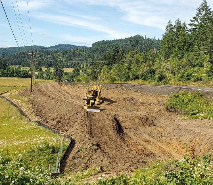
Drivers coming to and leaving Lorane to the north will need to plan for a little extra time these days. The Lane County Territorial Highway Project has finally begun in earnest and Phase One—the realignment and straightening of the curves at Stony Point (also spelled “Stoney Point”), about 3 miles north of town, is expected to continue through the summer and into the fall.
The entire project involves the stretch of Territorial Highway lying between Gillespie Corners and the community of Lorane and will be done in four phases over the next 3 years. Stony Point is the most critical and urgent part of the project, so it comes first.
Historically, early roads in the area, built by the first white settlers, usually traversed the sides of foothills. This was done because of the better drain-off on the hillsides during wet weather. Since gravel was not used until later years, the dirt roads in the flat lands became quagmires during rainy periods and dusty in the summer.
The Stony Point section of Territorial Road took a different route before 1920. As the original road started to ascend, its route cut farther east and went through the properties at the top of the hill and came out just south of the entrance to Territorial Lane where it continued on to Lorane as it does today.
Stony Point’s current route, climbs the hill leading into Lorane and has been a series of sharp, sweeping curves. But for several decades now, the road bed on the, then, state-owned highway, began slipping in three places. ODOT would arrive on an increasingly frequent basis to fill it with more gravel and pavement which, in turn, would once again slip off into the field below. The road is narrow and there were no shoulders going around those curves. The fog lines are right on the edges of downhill drop-offs on the west side and steep banks border the east side of the road.
During the last 20 years or so, traffic has been increasing, due to the popularity of our local wineries and access to the shortcut to the southbound I-5 freeway. Territorial Highway has become a popular route for bicyclists, too, so when the State of Oregon agreed to trade the oversight of Territorial Highway to Lane County for Beltline Road in Eugene, the county put a priority on realigning the road for safety’s sake. A large grant was obtained for the project and June 2020 was set for it to begin.
According to Lane County’s Summer 2020 Project Update, Phase One will soften the sharp curves of Stony Point and widen the road with shoulders and guardrails. The road will be stabilized to prevent future landslides and a retaining wall will be installed across the largest slide area. Flexible mesh (geotextile) material will be used to reinforce the soil. The new road will be built on top of the reinforced soil and the retaining wall.
During the construction, one lane of gravel road will be open for “bi-directional” travel and flaggers, pilot cars and temporary traffic signals will be used as needed. Lane County advises that bicyclists use alternative routes as the work zone will be steep and hard to navigate on a bicycle.
The county is hoping that Phase One will be completed by late fall 2020 so that Phase Two, between Gillespie Corners (where Lorane Highway meets Territorial Highway) and Easy Acres Drive, can begin on time next spring or summer in 2021. That section will address the frequent flooding we have during rainy winters that goes over the road as well as softening the curves in that area where accidents are common.
Phase Three, scheduled for 2022, will take out some of the sharp curves between Easy Acres Drive and Hamm Road, at the north end of Stony Point, and all phases will widen the road considerably with generous shoulders.
The final phase will finish up between Stony Point, to the south, and Cottage Grove-Lorane Road in 2023.
For those of you traveling in our area, please be aware that construction will be on-going for quite some time and expect delays. And, most of all… please drive carefully. Help us keep our family, friends and neighbors safe during this time.

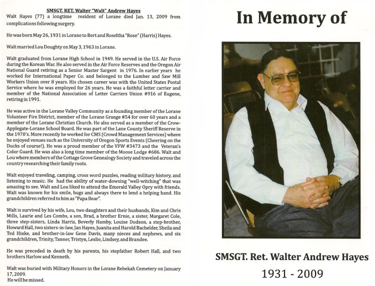 Walt loved telling stories about his heritage. The people who touched his own life and those of his family remained important to him and when Nancy O’Hearn, Marna Hing and I began researching the history of the area, Walt became one of our richest “fonts of knowledge.” He was able to tell us much about the people, with all of their special qualities and quirks and experiences, who once populated the valley; he pointed out where homes, mills and businesses once stood; he told stories that made us laugh and cry, bringing to life, once more, the people and the way of life that came before us. We learned what a fun-loving character Frank Davis was – how he taught the fine art of spitball making to the local boys during church and how he frequently became the focus of their pranks, especially around Halloween. Walt told about his mother, Rose Harris Hayes, and the special love he had for her. We learned about the farming practices of the old Lorane Orchards and how local people, young and old, were employed in planting, caring for and harvesting the pears, apples and plums that grew on the 1,800 acres where King Estate Winery now sits.
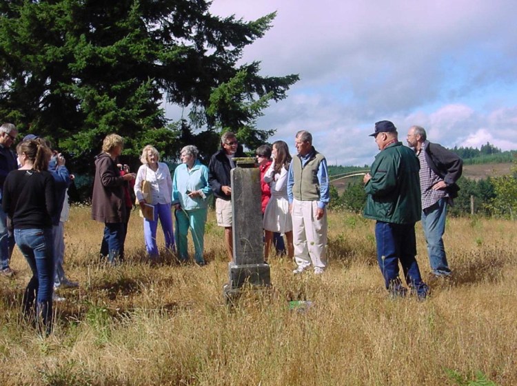 Twenty-three members of the Jost and Jerusha Petrie family contacted me about coming to Lorane to visit their ancestors’ gravesites and to see where they had once lived in the late 1800s and early 1900s. They were coming from Wisconsin, New York, Chicago and California to a wedding in Portland and planned to drive down to Lorane the next day. I asked Walt if he would be willing to be their tour guide. At first, he was afraid that he couldn’t… that he had some previous plans for that day… but I found out later, that he cancelled his plans to spend the day with the Petries, much to Lou’s frustration! We all met that morning at the Lorane Grange Cemetery and Walt showed us the large obelisk headstone marking the graves of Jost and Jerusha. I explained to the Petries that Walt was able to “witch” gravesites and had done so as a project for the Cottage Grove Genealogy Society so that they could map and mark the graves there. He agreed to give them a demonstration. As Walt walked across areas of ground near the headstone with his “L-shaped” devining rods in each hand, they pointed straight ahead, but as soon as he began to cross over one of the graves, they slowly began turning inward towards each other, crossing into an “X-shape.” He did it time and again while the family members watched in astonishment. Soon several of the Petries asked to try their hand at witching.